


FSWidgets QuickPlan

Descrizione di FSWidgets QuickPlan
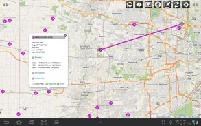
FSWidgets QuickPlan is a visual touch enabled flight planner that makes it easy to generate flight plans in native FSX, FS2004 or X-Plane formats.
For the folk commenting saying they didn't know it was a DEMO, we don't know how to make this any clearer. This is a DEMO only, the full version can be purchased from our site.
*** Please note, this is a DEMO VERSION ONLY ***
Demo is limited to the San Francisco (KSFO) region only, it is fully functional but will operate only in that region. For purchase details please visit our site and our store athttp://fswidgets.com. We provide this demo to give you the opportunity to test QuickPlan and ensure you are happy with its features. Should you decide to purchase, you will receive a key that will unlock the demo version.
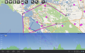
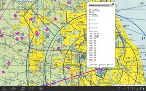
The entire route is generated visually, by tapping the map to add the departure airport, intermediate waypoints and arrival airport in the same order that you intend flying the plan.
Flight plans are saved and loaded using the SD card on the phone or tablet. Plans can be exported using any normal file browser on the Android device or by using standard Windows or Mac file management tools.
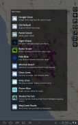
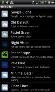
QuickPlan utilises a new mapping engine and includes 12 world-wide map styles and has support for FSWidgets Cloud Based Aero Chart products (free Cuba/Puerto Rico WAC Cloud Based Chart included) and the FSWidgets Cloud Based World Nav Data product (Free KSFO - San Francisco Bay area Nav Data included).
Main Features:
Supports tablets, hi-resolution phones, standard and low-end screens and devices
Generates native FSX (.pln), FS2004 (.pln) and X-Plane (.fms) format flight plans
Saves flight plans to the SD card, can be exported/imported
Flight plans can be exported via USB connection or SD card
Terrain profile display using the FSWidgets terrain engine
Search for airport by ICAO identifier
Map powered by CloudMade Leaflet API (using OpenStreetMap data)
Includes 14 world-wide maps styles
Supports FSWidgets Cloud Based Aero Charts
Free Cuba/Puerto Rico WAC Cloud Based Chart included
Supports FSWidgets Cloud Based World Nav Data
Free KSFO (San Francisco Bay) area Nav Data included
World-wide Metar and TAF Data icons
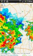
US Nexrad (Next-Gen Radar) Data
QuickPlan can be used in Freeform Mode, Advanced Mode, or a combination of both:
Freeform Mode:
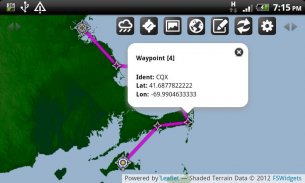
Simply tap anywhere on the map and QuickPlan will allow you to add it as a generic waypoint. VFR pilots often use towns, lakes and other unique geographic features and with QuickPlan you can add any geographical location shown on the base map. Plans created this way label the waypoints automatically with generic names (e.g. DEP, WP1, WP2, ARR).
If desired, the entire route from departure to arrival can be created without reference to any navigational aids or official airports. This is handy for bush pilots who often use unlicensed airfields and small landing strips (or seaplane landing areas). Helicopter pilots can also quickly create plans that depart from off-airport locations like building rooftops or land on a road.
Advanced Mode:
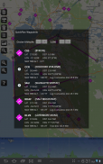
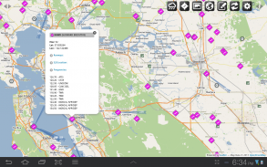
If you own the FSWidgets Cloud Based World Nav Data product you can create more advanced flight plans by tapping on any of the icons displayed on the map to add them as waypoints - airports, VOR's, NDB's and intersections (data for the KSFO area is included free). Plans created this way label the waypoints automatically with airport and navigational aid identifiers taken from the Nav Data (e.g. KSFO, OSI, LV, FABLA).
Who we are:
FSWidgets is a software development team based in Australia, specializing in add-ons for Microsoft Flight Simulator (Windows) and Laminar Research X-Plane (Windows, Mac, Linux). Both of its founding members have extensive experience in creating award-winning add-ons for flight simulators and have been active in the simming community for well over a decade.FSWidgets QuickPlan è un tocco visivo abilitato pianificatore di volo che lo rende facile generare piani di volo in FSX, FS2004 o X-Plane formati nativi.
Per la gente commentando dicendo che non sapevano che era una DEMO, non sappiamo come fare questo più chiaro. Si tratta di una DEMO solo, la versione completa può essere acquistato dal nostro sito.
*** Si prega di notare, questa è una versione demo SOLO ***
Demo è limitata alla regione San Francisco (KSFO) soltanto, è completamente funzionale ma funziona solo in quella regione. Per i dettagli di acquisto si prega di visitare il nostro sito e il nostro negozio ahttp://fswidgets.com. Forniamo questa demo per darvi la possibilità di provare QuickPlan e garantire sei felice con le sue caratteristiche. Se decidete di acquistare, si riceverà una chiave che sblocca la versione demo.
L'intero percorso è generato visivamente, toccando la mappa per aggiungere l'aeroporto di partenza, tappe intermedie e l'aeroporto di arrivo nello stesso ordine che si ha intenzione di volare il piano.
Piani di volo vengono salvate e caricate utilizzando la scheda SD del telefono o tablet. I piani possono essere esportati tramite qualsiasi browser normale file sul dispositivo Android o tramite strumenti standard di gestione dei file Windows o Mac.
QuickPlan utilizza un nuovo motore di mappatura e comprende 12 sugli stili di tutto il mondo e ha il supporto per i prodotti grafici FSWidgets Copertura Based Aero (libero Grafico Cuba / Puerto Rico WAC Copertura Basato incluso) e il prodotto FSWidgets Copertura Based World Data Nav (Free KSFO - San Area Francisco Bay Dati navigazione inclusa).
Caratteristiche principali:
Supporta tablet, cellulari hi-risoluzione, schermi standard di fascia bassa e dispositivi
Genera nativo FSX (. Pln), FS2004 (. Pln) e X-Plane piani (. FMS) ponti formato
Salva piani di volo sulla scheda SD, possono essere esportati / importati
I piani di volo possono essere esportati tramite connessione USB o scheda SD
Display del profilo del terreno utilizzando il motore di terreno FSWidgets
Ricerca di aeroporto per identificativo ICAO
Mappa powered by CloudMade Schemi API (utilizzando i dati di OpenStreetMap)
Include 14 mondiali mappe stili
Supporta FSWidgets cloud based Aero Grafici
Grafico gratuita di Cuba / Puerto Rico WAC cloud based incluso
Supporta FSWidgets cloud based World Data Nav
Libero KSFO (San Francisco Bay) Area dati Nav inclusa
Metar e TAF dati icone mondiali
US Nexrad (Next-Gen Radar) Dati
QuickPlan può essere utilizzato in modalità Freeform, modalità avanzata, o una combinazione di entrambi:
Modalità Freeform:
Basta toccare un punto qualsiasi della mappa e QuickPlan vi permetterà di aggiungere come waypoint generico. Piloti VFR utilizzano spesso le città, i laghi e le altre caratteristiche geografiche uniche e con QuickPlan è possibile aggiungere qualsiasi posizione geografica indicata sulla mappa di base. I piani creati in questo modo etichettare automaticamente i waypoint con nomi generici (es. DEP, WP1, WP2, ARR).
Se lo si desidera, l'intero percorso dalla partenza all'arrivo può essere creata senza riferimento ad eventuali aiuti alla navigazione o aeroporti ufficiali. Questo è utile per i piloti cespuglio che spesso utilizzano aeroporti senza licenza e piste di atterraggio per piccoli gruppi (o aree di atterraggio idrovolanti). Piloti di elicottero può anche creare rapidamente piani che partono da posizioni off-aeroporto, come tetti di edifici o terreni su una strada.
Modalità avanzata:
Se si possiede il prodotto FSWidgets Copertura Based World Data Nav è possibile creare piani di volo più avanzate toccando una delle icone visualizzate sulla mappa per aggiungerli come waypoints - aeroporti, VOR, NDB e intersezioni (i dati per l'area KSFO è incluso gratuito). I piani creati in questo modo etichettare automaticamente i waypoint con l'aeroporto e aiuti alla navigazione identificatori prelevate dal Dati navigazione (ad esempio KSFO, OSI, LV, fabla).
Chi siamo:
FSWidgets è un team di sviluppo software con sede in Australia, specializzata in add-on per Microsoft Flight Simulator (Windows) e Laminar Research X-Plane (Windows, Mac, Linux). Entrambi i suoi soci fondatori hanno una vasta esperienza nella creazione premiato add-on per simulatori di volo e sono attivi nella comunità simming per oltre un decennio.
FSWidgets QuickPlan - Versione 2.2 - Jan 24, 2015
(08-02-2015)
FSWidgets QuickPlan - Informazioni APK
Versione APK: 2.2 - Jan 24, 2015Pacchetto: com.fswidgets.quickplanUltima versione di FSWidgets QuickPlan
Altre versioni


App nella stessa categoria

Potrebbe piacerti anche...


